Hope Fire Update... weekend smoke possible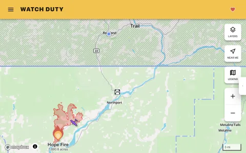
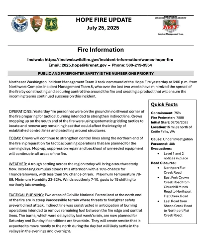
You gotta love RAIN! The Hope Fire near Northport reached almost 8,000 acres, with over 1200 people fighting it this week. The rain and north wind helped us all. The forecast is for hot and dry again, with SW winds. Now the fire crew is scaled back to 488. They plan to light control burns on the north end of the fire this weekend. Here is today's update, JULY 25: Inciweb: https://inciweb.wildfire.gov/incident-information/wanes-hope-fire Email: 2025.hope@firenet.gov – Phone: 509-219-9554 PUBLIC AND FIREFIGHTER SAFETY IS THE NUMBER ONE PRIORITY Northeast Washington Incident Management Team 3 took command of the Hope Fire yesterday at 6:00 p.m. from Northwest Complex Incident Management Team 8, who over the last two weeks have minimized the spread of the fire by constructing and securing control line around the fire and creating a product that will ensure the incoming teams continued success on this incident. OPERATIONS: Yesterday (Thurs 24) fire personnel were on the ground in northwest corner of the fire preparing for tactical burning intended to strengthen indirect line. Crews mopping up on the south end of the fire were using systematic gridding tactics to locate and remove any remaining heat that could affect the integrity of established control lines and patrolling around structures. TODAY: Crews will continue to strengthen control lines along the northern end of the fire in preparation for tactical burning operations that are planned for the coming days. Mop-up, suppression repair and backhaul of unneeded equipment will continue in all areas of the fire. WEATHER: A trough settling across the region today will bring a southwesterly flow. Increasing cumulus clouds this afternoon with a 10% chance for Thundershowers, with less than 5% chance of rain. Maximum Temperature 78- 89, Minimum Humidity 23-32%, Winds southerly 7-10, gusts to 15 shifting to northerly late evening. TACTICAL BURNING: Two areas of Colville National Forest land at the north end of the fire are in steep inaccessible terrain where threats to firefighter safety prevent direct attack. Indirect line was constructed in anticipation of burning operations intended to remove remaining fuel between the fire edge and control lines. The burns, which were delayed by last week’s rain, are now planned for Saturday and Sunday if conditions are favorable. They will create smoke that is expected to move mostly to the north during the day but will likely settle in the valleys in the evenings and overnight. Quick Facts Containment: 75% Fire Perimeter: 7880 Initial Start: 07/08/2025 Location:15 miles north of Kettle Falls, WA Cause: Under Investigation Personnel: 488 Evacuations: • Level 1 and 2 notices in place Road Closures: • Northport Flat Creek Road • East Fork Crown Creek Road from Churchill Mines Road to Northport Flat Creek Road • Lael Road from Sheep Creek Road to Northport Flat Creek Road. |